www.McMurray.info |
||||||||||||||||||||||||||||||
County Down, Ireland
|
| Place Name | Parish | Map Ref | Information | Reference |
|---|---|---|---|---|
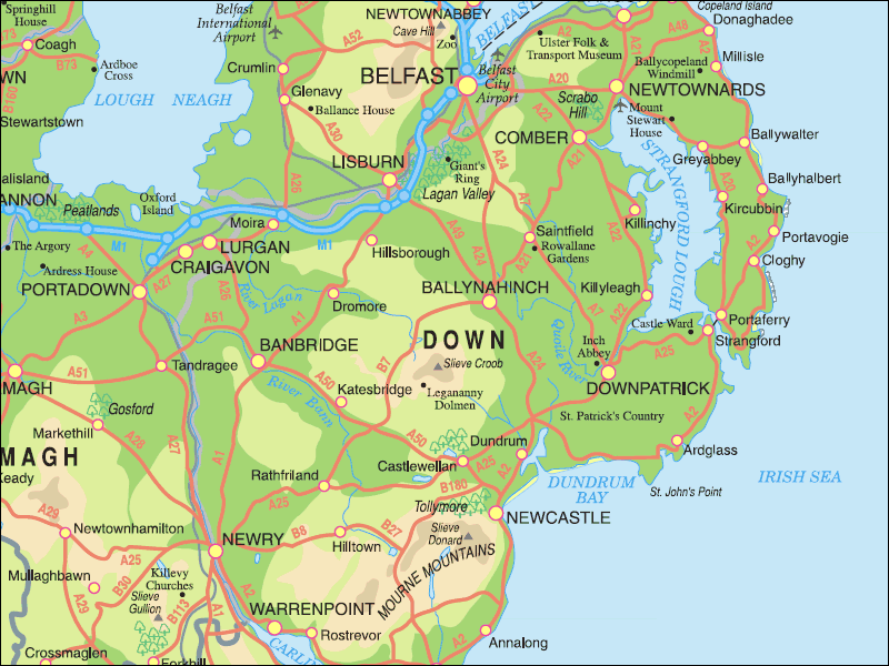
| Drumlough | Dromore | 20: 26/56 | A townland 6km NW of Dromore; 1092 acres; click here to see its location on a townland map; means ' ridge of the lake'; has hills & bogs & Drumlough Moss; Presbyterian church here. | V12 p 71, 72, 73, 76 OSM : GIPR: PNNI V6 p 122 |
| Ballyboley | Greyabbey | 21: 57/70 | 3km N of Grey Abbey; 783 acres; click here to see its location on a townland map; means 'townland of the summer pasturage'; in 1659 there were 4 English/Scots & 4 Catholic families; an area of bog; school established in 1834; Ballyboley Races 6 Apr 1872 (NI); ; Irish Land Act meeting 24 Mar 1894; Land Bill meeting 4 Jul 1896 (NC) | V17 p123 V7 p 67, 69, 70 OSM; SP; GV; DR; NC; PNNI V2 p 201 |
| Killinchy | Killinchy | 21:50/61 | a parish & a town & townland of 555 acres; click here to see its location on a townland map; means 'church of St. Duinseach'; click here for photos and more information | n/a |
| Lisbarnet | Kilmood | 21: 47/65 | 3km SE of Comber; 632 acres; click here to see its location on a townland map; to be sold by auction 62 acres in Lisbarnet 21 Apr 1792; in 1831 there were 65 houses; 43 families employed in agriculture & 8 in trade; 180 males & 184 females; 14 servants; the proprietor then was Lord Londonderry whose agent was Mr J. Andrews of Comber; farms were from 2 - 30 acres; rent was 20- 34 shillings an acre; middling quality land; one school here in 1836; crops were potatoes, wheat & oats; incendiary fire, tenants meeting 2 Mar 1850 | NS; V7 p 94,95 OSM: DR |
| Tullynakill | Tullynakill | n/a | A small parish & a townland of 317 acres; click here to see its location on a townland map; proprietor was Sir James Hamilton in 1615; the proprietors in 1836 were Rev. Mr Boyd of Dromara & A.M. Young of Belfast as trustee; good land; rents were 20 shillings an acre; Church of Ireland built in 1826; Cattle show: farming society 21 Jan 1843; Robert Murland bought the limestone quarries in 1864 | V7 p 122-124 OSM: DR; O'L B p 320; NDM p111 |
County Down Links
In the interests of information, the following links contain general information about County Down:
©Copyright 2006-2022, the McMurray Family